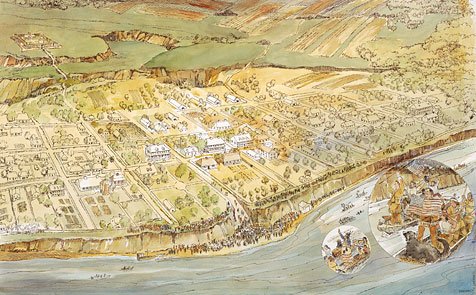
This is a painting of an overview of Saint Louis circa 1806 with the Corps of Discovery in their dugout canoes coming down the Mississippi River to dock at the foot of Market Street. The townspeople, 1000 strong, line the banks of the 40 foot bluff the old city stood on-- the site of the Gateway Arch today.
St. Louis Welcoming Lewis & Clark, September 23.1806
The day was overcast; the time 12 o'clock noon. Those thought dead were returning. Jubilant townspeople, 1000 strong, line the 40 foot bluffs, cheering and waving white cloths of welcome. The artist used the technique of a zoom lens to show a close-up of Lewis & Clark in their dugouts responding with the same enthusiasm as the crowds. Lewis is holding the large American flag, the symbol of their authority, he had carried to the Pacific Ocean and back. Smaller replicas of this flag> were given to scores of Indian chiefs and braves.
St. Louis began as a fur trading post founded and laid out by Pierre Laclede Linguest, a French fur trader from New Orleans, in 1764. He predicted from the beginning that "this settlement will become one of the finest cities in America." It became a part of the United States with the Louisiana Purchase in 1804.


Map of St. Louis Circa 1806
This is a painting of an overview of Saint Louis circa 1806 with the Corps of Discovery in their dugout canoes coming down the Mississippi River to dock at the foot of Market Street. The townspeople, 1000 strong, line the banks of the 40 foot bluff the old city stood on-- the site of the Gateway Arch today.
St. Louis Welcoming Lewis & Clark, September 23.1806
The day was overcast; the time 12 o'clock noon. Those thought dead were returning. Jubilant townspeople, 1000 strong, line the 40 foot bluffs, cheering and waving white cloths of welcome. The artist used the technique of a zoom lens to show a close-up of Lewis & Clark in their dugouts responding with the same enthusiasm as the crowds. Lewis is holding the large American flag, the symbol of their authority, he had carried to the Pacific Ocean and back. Smaller replicas of this flag> were given to scores of Indian chiefs and braves.
St. Louis began as a fur trading post founded and laid out by Pierre Laclede Linguest, a French fur trader from New Orleans, in 1764. He predicted from the beginning that "this settlement will become one of the finest cities in America." It became a part of the United States with the Louisiana Purchase in 1804.